

^^^^ nice video. Thanks for posting


 1 votes
Folsom Lake Level Discussion - Mormon Island Exposed
Started by
4thgenFolsomite
, Dec 23 2013 08:48 AM
yes its officially drought
194 replies to this topic
#121

caligirlz
-

- Moderator
-

- 3,163 posts
Living Legend
- Gender:Female
- Location:Folsom
Posted 09 January 2014 - 09:49 PM
#122
WolfMom
-

- Premium Member
-

- 549 posts
Superstar
- Gender:Female
- Location:Folsom, CA
- Interests:Having fun with the family. :-)
Posted 11 January 2014 - 11:00 AM
Rain folks! Droplets fell on my face as I was walking the wolf-dog today. I am getting ready to go out and play in it as promised! 
Dawn Grove
#123
Judge Smails
-

- Premium Member
-
- 403 posts
All Star
Posted 11 January 2014 - 11:48 AM
Strange wet things falling from the sky. Does anyone remember what they are called?
#124
WolfMom
-
- Premium Member
-
- 549 posts
Superstar
- Gender:Female
- Location:Folsom, CA
- Interests:Having fun with the family. :-)
Posted 11 January 2014 - 12:12 PM
Strange wet things falling from the sky. Does anyone remember what they are called?
VERY SMALL ROCKS! (Oh, no that is the answer to: "What else floats on water?")
Sorry, still giddy from going out with friends and family and dancing in those strange falling thingies!
Dawn Grove
#125
Silverado
-

- Photographer
-

- 782 posts
Superstar
- Gender:Male
- Location:Pairie Oaks
- Interests:Photography, ATVs, Jeepin', the Great Outdoors
Posted 12 January 2014 - 09:25 PM
So another interesting day at the lake. This appears to be an old grave site / cemetery.


The old topo map seems to confirm that is was indeed a cemetery when referenced to GPS coordinates.

I initially thought I had found the original Mormon Island Cemetery, however I could not find the name Wild in the relocation cemetary roster.
So not sure what this is.

The inconsistencies are so compounded as to present a seemingly impossible phenomenon. -Mr. Spock
#126
4thgenFolsomite
-
- Premium Member
-
- 5,979 posts
Hopeless Addict
Posted 13 January 2014 - 02:19 AM
The Wild family go way back in our history and one of t he descendants owns the building where Greys Antiques is today. Nice people.
Knowing the past helps deciphering the future.
#127
WolfMom
-
- Premium Member
-
- 549 posts
Superstar
- Gender:Female
- Location:Folsom, CA
- Interests:Having fun with the family. :-)
Posted 13 January 2014 - 05:24 AM
I love how much I am learning with these posts! Thanks for the pictures and history bits folks!
Dawn Grove
#128
chris v
-
- Premium Member
-
- 4,373 posts
Living Legend
- Gender:Male
- Location:Broadstone
Posted 13 January 2014 - 07:14 AM
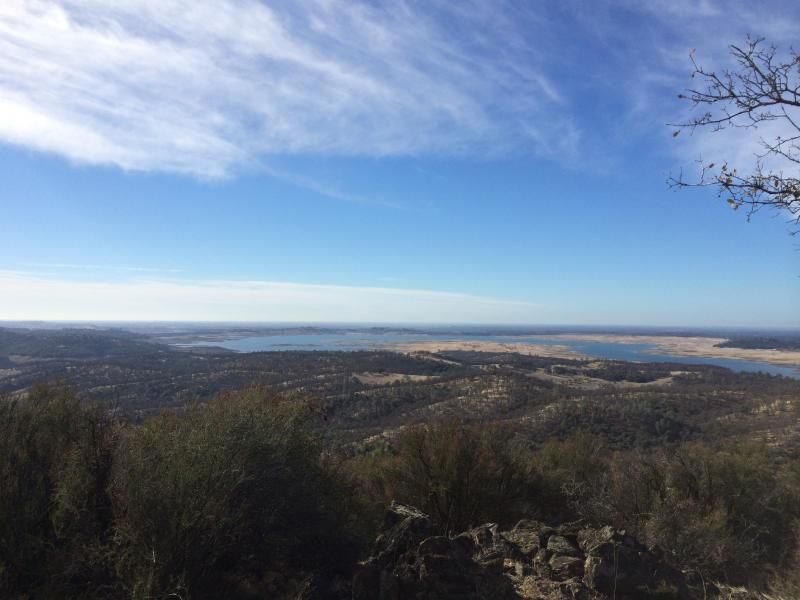
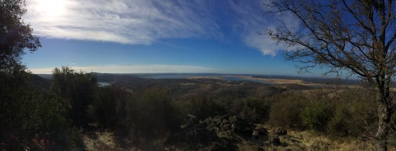
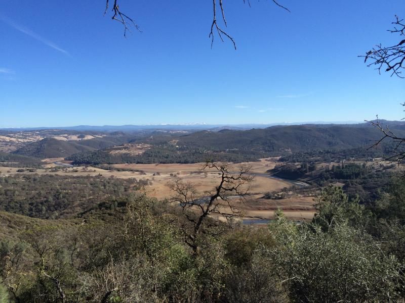
Alright, I have some new pictures from this last weekend. This is from the highest point around Folsom Lake from an elevation close to 1500' Gives a good overall view of the lake.
#129
JMB83
-

- Premium Member
-
- 108 posts
Veteran
- Gender:Male
- Location:Folsom Lake
Posted 14 January 2014 - 11:30 PM
Great thread! I walk out near Browns Ravine Marina all the time. Over the years, I've found loads of neat stuff, and am happy that families/kids are out exploring. Some oddities and random findings of late:
A survey marker, somewhat between the cemetery and the tractor tires, but more north:

Looks like Barack Obama carved his name into this rock... but hadn't met Michelle yet ;-)

A little more close-up of the school foundation:

More later...
#130
john
-

- Admin
-

- 9,841 posts
Founder
- Gender:Male
- Location:Prairie Oaks
Posted 15 January 2014 - 01:24 PM
Found an old book which had the history of Mormon Island:
In the spring of 1852 two Mormons one of whom was Woodruff when on their way from Sutter's Mill to the fort themselves near sunset at the spot known as Willow Springs in county. Concluding to camp they shot a deer and went to the point on the American river where they could procure water and for their horses.
They descended the bluff to a flat covered underbrush and cooked and ate their supper. As it was not yet one of them said "They are taking out gold above us on the Let us see if we can find some here". They took a tin pan off some of the top soil and panning out the dirt obtained a fine. They went to the fort the next day and informed Sam of the firm of Smith & Co who traded goods for hides and wheat at their trading post Brannan was at that time the guide and director of the Mormons of the New Helvetia other districts of the state. He went to where they found the set up a preemption claim and demanded one third of all the taken from the bar. So long as the Mormons were largely in majority among the miners this royalty was exacted religiously as unbelievers flocked in they resisted Brannan's claim and he compelled to give up the collection of royalty.
He had accumulated several thousand dollars with which he formed a partnership with Mellus Howard & Co of San Francisco and this laid the foundation for his large fortune. The place was named Mormon island.
As the news of the discovery spread miners flocked in from all quarters till in 1853 the town had a population of about twentyfive hundred people nine hundred of whom were voters. The first hotel was called the Blue Tent and was opened by SR Caldwell soon after the island began to be populated was moved to another part of the town and christened the Caldwell House in 1852 and was discontinued in 1854. Sam Brannan opened the first store in 1848 sold to James Queen he to Captain Pool and he in turn to Dewitt C Stanford a brother of Governor Stanford who died in Australia while on a business trip. JP Markham opened a hotel and store in 1850 and closed it in 1854 Two stage lines running to Mormon island were established in 1850 one being from Sacramento to Coloma and the other from Sacramento to the island. They were both taken off in 1856 and at the same time a line was started from Folsom to Coloma running through Mormon island.
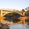
The postoffice was opened in 1851 with J V Shaw as postmaster Dallas & Kneass opened the Miner's hotel in 1851 and it was burned in 1856 and never rebuilt The Mansion House was kept by Thomas Stephenson from 1853 to 1856 and then closed In 1856 a fire destroyed the southwest portion of the town which was never rebuilt; At one time there were four hotels three dry goods and five general stores Adams & Co s Express oflice carpenter shop butcher shop bakery livery stable and seven saloons in Mormon island; A school was opened in 1851 and there is now a good school building there; The principal bridge in the township is known as the Mormon island bridge. The first one was built by J W Shaw in 1851; It was a wooden bridge and was washed away by high water in 1854. He built a wire suspension bridge the next summer which was washed away in the flood of 1862 and was rebuilt by Shaw A few years ago this was replaced by a higher and more costly one by the supervisors of this and Eldorado counties.
The first ball in the county was given at Mormon island in the jolly old days of 1849 and a humorous account of it was given in the Record Union of June 21 1873. Many public houses existed on the roads in the township which no data have been secured. The Smith Exchange was built on the Sacramento and Coloma road near Mormon island by a man that name in 1853 and was the largest public house in the township at that time. He sold out in the fall of 1855 to Cox & Hamilton who sold to William Jarvis in 1858. He sold to a man named Lee It was discontinued for a year when Freeman McComber bought it and fitted it up and it was finally closed in 1864. The Union Tavern was probably opened as early as 1850 by Mr Turle and closed in 1855. The Half way House was built by Briggs & Hoffman in 1852 sold a year to one Martin who sold in turn to John E Butler.
#131
john
-
- Admin
-
- 9,841 posts
Founder
- Gender:Male
- Location:Prairie Oaks
Posted 15 January 2014 - 03:39 PM
How dry is Folsom Lake? Worse than the drought of 1976-1977. The current size of Folsom Lake is about at the lowest point of our worst drought year since the dam was built.
http://cdec.water.ca...ction?resid=FOL
Here's a photo of 1977 - our historical low. If this was the lowest point, it was in September. We still have 9 months. 
#132
Johnjohn
-

- Registered Members
-
- 20 posts
Netizen
Posted 16 January 2014 - 01:51 PM
Great thread! I walk out near Browns Ravine Marina all the time. Over the years, I've found loads of neat stuff, and am happy that families/kids are out exploring. Some oddities and random findings of late:
A survey marker, somewhat between the cemetery and the tractor tires, but more north:
Looks like Barack Obama carved his name into this rock... but hadn't met Michelle yet ;-)
A little more close-up of the school foundation:
More later...
O.o a survey marker. this will help me dial my maps in more. thanks!
#133
Johnjohn
-
- Registered Members
-
- 20 posts
Netizen
Posted 16 January 2014 - 02:30 PM
i found a 1866 survey of the area. with townsfolk's houses named on it in some BLM records.
link below is the search results from BLM Records
http://www.glorecord...sultsTabIndex=1
click Plat Image icon for 1866 survey to see the map i am talking about.
the S16/S17 shows where that marker is on the grid
S20/S21
there is a bunch of other stuff im digging through right now.
#134
kanda
-
- Premium Member
-
- 555 posts
Superstar
- Gender:Male
Posted 16 January 2014 - 05:18 PM
How dry is Folsom Lake? Worse than the drought of 1976-1977. The current size of Folsom Lake is about at the lowest point of our worst drought year since the dam was built.
For those too lazy to click on John's link, it's a scary sight indeed. The lake currently contains 171,034 AF (acre feet, I assume?), which is 18% of total capacity, and 34% of the normal, historical average capacity on this date. At the same period during the 1976-77 drought, the lake had about 280,000 AF.
#135
Silverado
-
- Photographer
-
- 782 posts
Superstar
- Gender:Male
- Location:Pairie Oaks
- Interests:Photography, ATVs, Jeepin', the Great Outdoors
Posted 16 January 2014 - 06:52 PM
i found a 1866 survey of the area. with townsfolk's houses named on it in some BLM records.
link below is the search results from BLM Records
http://www.glorecord...sultsTabIndex=1
click Plat Image icon for 1866 survey to see the map i am talking about.
the S16/S17 shows where that marker is on the grid
S20/S21
there is a bunch of other stuff im digging through right now.
What a great map! Hours of fun.
Thanks for posting.
The inconsistencies are so compounded as to present a seemingly impossible phenomenon. -Mr. Spock


0 user(s) are reading this topic
0 members, 0 guests, 0 anonymous users

